Showing posts with label weather. Show all posts

Friday, February 18, 2022

Wind gusts cause power outages in Rockville this morning


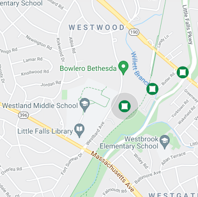
Gusty winds are bringing down trees and power lines, and causing power outages this morning in Montgomery County. There are currently three outages in the Westbard area, with a crew assigned to the largest of the three, which impacts 43 Pepco customers. 

Small outages currently affect about 5 customers each in the Chevy Chase/Martin's Additions area, the area between Tilden Lane and Montrose Parkway, the area near the Target on Bou Avenue, an area south of Bells Mill Road off of Gainsborough Road, customers along Falls Road near Potomac Village and the Bullis School, and East Rockville just east of the CSX/Metro tracks.


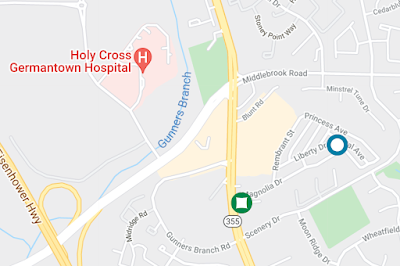
Major outages are found further north along I-270. 710 customers are in the dark along the Watkins Mill Road corridor between MD 355 and Montgomery Village. 98 customers are impacted by an outage between Scenery Drive and Middlebrook Road east of MD 355 in Germantown. A small outage near Kingsview Middle School in Germantown currently affects 5 customers.

Expect more outages, with wind gusts between 20 and 50 MPH until late morning. Watch for downed trees, falling limbs and live power lines they may hit and displace. Bring in all unsecured objects that might blow away from yards or balconies.

Wednesday, September 1, 2021

Rockville experiences heavy lightning, some serious flooding in overnight storm


UPDATE - September 1, 2021 at 12:19 PM: Montgomery County police are now asking that any residents of the Rock Creek Woods apartments who left the complex please call them at 301-279-8000, so that they can be accounted for

11:52 AM: Officials have announced that one person has died, and a second is missing in the flooding at Rock Creek Woods apartments on Twinbrook Parkway this morning

A storm that passed through Montgomery County around 3:30 this morning had Rockville in its direct path. Residents unlucky enough to be out on the roads encountered flooding and high water, including along Rockville Pike. 

A resident of Congressional Towers reported water in his apartment as high as seats of the chairs in the room, and said he and others were rescued from the building minutes later by the Rockville Fire Department. Montgomery County Fire and Rescue Services spokesperson Pete Piringer said that residents of basement apartments in the 13200 block of Twinbrook Parkway had to be rescued, as well.

About 224 Pepco customers are without power right now in Rockville, particularly in the Twinbrook, King Farm and Rockshire areas.

Tuesday, December 15, 2020

Maryland SHA treating MD 355 ahead of Wednesday snow event


A significant snowstorm approaching the northeast is expected to drop up to 3 inches of snow on Montgomery County Wednesday into Thursday. The key variable will be how much comes down as snow, and how much as rain. Maryland's State Highway Administration isn't taking any chances. Rockville Pike (MD 355) had already received a layer of deicing solution between Rockville and downtown Bethesda last night, 24 hours before the storm was even expected to arrive.


Friday, February 7, 2020

Rare February severe storm hits Montgomery County

Damaged car on
Norbeck Road
Montgomery County is being pounded by severe storms this morning. A tornado was issued for parts of Gaithersburg and Germantown, as well as the northeast corner of the upcounty near the Howard and Carroll County borders. Flooding has been reported across the upcounty, as have fallen trees and power lines. The whole county is being hit by the unusual February summer-style storm, but the upcounty is being affected the most.
Power lines, tree down on
Darnestown Road at
White Ground Road
Montgomery County Fire and Rescue Services have received so many emergency calls that they are now operating under Condition Red, which means there may be longer response times, particularly for non-critical incidents. Violent weather and storm damage have also impacted parts of Poolesville, Rockville and Silver Spring, most notably in the Dawsonville, Norbeck Road and Layhill Road areas.

Route 109 is currently blocked between MD 355 and the I-270 overpass after a tree fell across the roadway. Some lanes are also blocked at Route 28 and Route 107. Trees are also reported down by MCFRS on Circle Gate Drive in Germantown.

Photos by Pete Piringer/MCFRS

Sunday, March 16, 2014

ROCKVILLE SNOW UPDATE - HOW MANY INCHES OF SNOW IN ROCKVILLE?

A winter storm warning is in effect across the region today from 2:00 PM until 2:00 PM Monday. Rain is forecast to begin this afternoon, and change over to snow as the sun sets. The heaviest snow will fall during the overnight hours tonight. Currently, the National Weather Service is calling for accumulation of 5 inches, or more. Temperatures will be in the 20s overnight.

Winds during the storm will gust up to 20 MPH, but average around 10.

Highs on Monday will remain in the lower 30s, meaning travel will be dangerous, and road conditions could remain hazardous throughout the day.

Stay tuned for updates on this very late winter storm.

Wednesday, February 5, 2014

ROCKVILLE ICE/WEATHER UPDATE (PHOTO)

It is currently 32° in Rockville. Expect rain or freezing rain intermittently over the next few hours, but this further precipitation shouldn't stick once the temperature increases.

Temperatures will remain above freezing all day, and the Winter Storm Warning expires at 10:00 AM this morning.

We're not thawed out yet, though, as you can see on this Ride On sign.

Monday, February 3, 2014

ROCKVILLE SNOW FORECAST - WEATHER

The snow forecast for Rockville is insignificant today. Expect a mix of rain and snow between early morning and mid-afternoon. Temperatures are forecast to remain above freezing throughout the day. Clouds will give way to clear skies by 8:00 tonight, but temperatures will drop below freezing - expect them to be in the upper twenties overnight.

Wednesday, March 6, 2013

ROCKVILLE SNOW UPDATE - WINTER STORM SATURN

Well, so far the weather experts have been dead wrong on Winter Storm Saturn. Rain starting at 5 PM yesterday? Never happened. 1-3" of snow last night? Nope. Now they're telling us the worst is still to come today. I don't have much faith in these "experts."

Roads are slick but quite passable at this hour.

Schools and the federal government are closed. The Maryland state government is on liberal leave.

Almost all Metrobus routes are running, but some are on "limited" schedules. That means more waiting than usual at bus stops.

Forecast remains the same, with snow accumulation of 5-6" by tomorrow, while other models say anywhere from 3-12".

Stay tuned here and at @RockvilleNights on Twitter for updates.