Showing posts with label snow. Show all posts

Friday, March 11, 2022

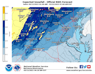
Winter weather advisory issued for Rockville, Montgomery County Saturday, 1-2" snow accumulation possible


The National Weather Service has issued a winter weather advisory that includes Montgomery County for tomorrow, Saturday, March 12, 2022, from 6:00 AM to 3:00 PM. Accuweather and the NWS are forecasting a potential accumulation of 1-to-2 inches of snow. 

While snow is not expected to accumulate by any significant degree on roads and sidewalks, due to warmer temperatures, they will still be slippery from mixed precipitation. Winds may gust up to 50 MPH, causing trees and limbs to fall, and power outages. 

Rain is expected to begin after midnight tonight, and turn to snow around 10:00-11:00 AM Saturday. The temperature will steadily drop throughout the day on Saturday, reaching a brutal low of 19 degrees at 6:00 AM Sunday, with potential for icy spots on wet surfaces. 

Image courtesy National Weather Service

Thursday, February 18, 2021

Rockville declares snow emergency


The City of Rockville is now under a snow emergency, as snow, sleet and ice are expected to result in 3-5 inches of accumulation today. All vehicles must be removed from roadways within the City of Rockville limits, and parked in driveways or garages. 

If there is no off-street parking available, vehicles should be parked along the even-numbered side of the street. On courts or cul-de-sacs, parking is allowed only on the left side of the streets as one enters the cul-de-sac or court. Do not park in the bulb of the court or cul-de-sac.

The city is making satellite parking available for residents in the following locations:

Rockville Civic Center main mansion lot, 603 Edmonston Drive.

Woodley Gardens Park, 900 Nelson Street.

Welsh Park (Mannakee Street side only), at the corner of Martins Lane and Mannakee Street.

Elwood Smith Community Center, 601 Harrington Road.

Tuesday, December 15, 2020

Maryland SHA treating MD 355 ahead of Wednesday snow event


A significant snowstorm approaching the northeast is expected to drop up to 3 inches of snow on Montgomery County Wednesday into Thursday. The key variable will be how much comes down as snow, and how much as rain. Maryland's State Highway Administration isn't taking any chances. Rockville Pike (MD 355) had already received a layer of deicing solution between Rockville and downtown Bethesda last night, 24 hours before the storm was even expected to arrive.


Wednesday, January 27, 2016

Assessing MoCo's snow response + Rockville transit schedule update

A Montgomery County voter
is asked if he remembers voting
for the County Council and Executive
who presided over the blizzard fiasco
Here's an update on the current status of transit services, snow plowing, and pedestrian/cycling facilities in Montgomery County. Before scrolling down, let's assess the County's blizzard fiasco and what can be changed to avoid another one. The experience of the last few days has shown there are several areas in which the County needs to improve its storm response capabilities.

One telling sign is that DC had over 600 pieces of equipment to move and clear snow. Montgomery began with over 700, and was up to 800 pieces in the last couple of days. Should a jurisdiction as large as MoCo have not much more equipment than the smaller District of Columbia? That's a clear indication, along with the results and many complaints, that MoCo did not have sufficient assets and personnel in place. Snow operations personnel have been working hard around the clock; there simply weren't enough of them.

Second, we've been told 311 will "get it done". Several residents around the County told me they could not get an answer from that County service line yesterday. Later, the County acknowledged that a record number of calls to 311 were received, and that many did not go through. 311 had more calls in one half-hour period Tuesday than it usually receives in an entire day. This was largely due to the number of unplowed streets residents were calling to complain about.

Third, despite Councilmember Hans Riemer's claims of being an open data guru, the storm fiasco helped bring to light that - five years after Riemer took office - the County's online Plow Tracker map isn't actually a real-time app, and isn't being instantly updated from GPS systems on trucks as we were led to believe. The map should be updated to provide that. Of course, a fancy map won't mean much if the County doesn't have enough personnel and trucks on hand to get the job done.

Fourth, Riemer's sidewalk-clearing law has been a complete bust. It's not being enforced, and we're getting the same dangerous results this time as pedestrians are forced to enter the roadway into oncoming traffic. Riemer took an unwarranted election year victory lap after passage of his law, as local media sycophants cheered him on. According to a Gazette (much missed - not!) report at the time, "the legislation seeks to ensure sidewalks are passable after storms and should improve how the county fulfills the intent of its law requiring snow removal, bill sponsor Councilman Hans Riemer said. 'The goal of this bill is to make our county more walkable in every season,' Riemer (D-At Large) of Takoma Park said."

Are you finding sidewalks around the County "walkable" today? I thought he said "every season." Cost of Riemer's law, the public education component that would magically move property owners to obey it, and the County implementation of it? $6,458,000, according to the Gazette.

We are being governed by some very incompetent people, folks.

UPDATES

Metro has announced that the Silver Line is back in service as of this morning, meaning the entire Metrorail system is now operational 82 hours after the snow stopped falling in the DC-area. Metrobus is operating under a Moderate Snow Schedule. The T2 is back in service today (Friendship Heights-Rockville via River Road). Many of the J routes remain out of service.

MetroAccess will operate on regular hours today.

All Ride On routes will have service on the S-Plan schedule.

Free parking in County public garages and lots has been extended through 9:00 AM tomorrow, January 28.

The Capital Crescent Trail has been plowed, is open, and still slick in spots; caution is advised.

The Bethesda Circulator bus will not operate again today.

A tractor-trailer jacknifed in the southbound lanes of I-270, leaving the local lanes temporarily blocked as rush hour got underway this morning.

Montgomery County's plow tracker map indicates that all streets that hadn't been reached yesterday in Springfield, Green Acres, Wood Acres, Spring Hill, Mohican Hills, Randolph Hills, Rock Creek Palisades, Stoneybrook Estates, and Aspen Hill have now been completed.

Most residents' assessment of Montgomery County's response to the storm is decidedly less positive than that expressed by County Executive Ike Leggett yesterday at a press conference. Leggett was not pressed to apologize by media, unlike DC Mayor Muriel Bowser, who did issue an apology.

Leggett promised every street in the County would have at least one lane cleared by 7:00 AM this morning. I've located only one complaint so far after the deadline passed, from a service road resident on Connecticut Avenue in Silver Spring. If your street has not been plowed yet, send me an email at robert [at] robertdyer [dot] net and call 311 to report it.

Bobcat loaders and plows worked all through the night to remove and move snow in downtown Bethesda and in neighborhoods along the River Road corridor.

In the Springfield neighborhood, one resident with an unplowed street flagged down a passing pickup truck with a snowplow attached to the front. After some negotiations, the pickup's driver began to plow part of the street for a cash payment. The private sector had provided service before the taxpayer-funded public sector in a classic free-market exchange.

Sidewalks remain snowdrifts in many places, including along River Road in Bethesda, and in front of the Columbia Country Club in Chevy Chase. Leggett acknowledged the widespread problem for pedestrians at his news conference, but has not yet produced a plan of action to address it.

Tuesday, January 26, 2016

MoCo, WMATA, Ride On slow to recover from blizzard

Grey lines indicate streets
where plowing has yet
to begin; map image from
7:20 AM today
A snow emergency remains in effect as Montgomery County and WMATA continue to struggle in recovering from Winter Storm Jonas. Montgomery County Public Schools are closed again today, and County snow plow crews are now tackling neighborhood streets.

According to the County snow operations map, some neighborhoods' streets remain untouched 59 hours after the snow ended. Spring Hill, Green Acres, Springfield, Wood Acres, Rock Creek Palisades, Randolph Hills, Stoneybrook Estates, and parts of Aspen Hill are among the "children of a lesser god."

The crews are working hard, but it appears the County did not procure enough of them in advance, despite the unusual advance notice of this weather event.

The other gaffe today is the County's Ride On bus service. Only Routes 1, 5, 8, 15, 16, 17, 23, 30, 34, 43, 46, 47, 55, 56, 59, 83, 100 will operate today, and - get this - only from 10:00 AM until 6:00 PM. What is this, just for senior citizens or something?! Unplowed neighborhood roads + no rush hour Ride On feeder buses = residents unable to get to work today.

Apparently, just because elected officials can declare themselves closed for a day off, they've lost touch with the fact that most of their constituents lack such authority. At last check, janitors can't telework. The failure to get the basic emergency transit service up and running is costing people pay, and possibly their jobs.

Unbelievably, once again there is no T2 Metrobus service along the River Road corridor. When you need transit in Montgomery County, it's just not there for you, folks. You can't rely on it.

Metrorail is operating with service on all lines except the Orange Line between Vienna & Ballston, and the Silver Line.

The Bethesda Circulator will not run today.


Saturday, January 23, 2016

Rockville snow and power outage update #WinterStormJonas #Jonas #Blizzard2016

Just before 1:00 AM there was a power outage near Shady Grove Road near King Farm and Interstate 270. Five customers were affected, but Pepco reports service has now been restored.

The worst of the storm is just arriving in the area. Wind gusts are projected to be 45-65 MPH through 1:00 PM today. Winds are currently 5 MPH in Rockville.

Snow accumulation around Rockville ranges from 4.8-5.1" at last report.

Current temperatures around Rockville:

Woodley Gardens: 20.8°F

Watts Branch Parkway: 20.8°

Twinbrook: 21.9°

Thursday, January 21, 2016

MoCo snow fiasco (Photos)

A minimal snowstorm downplayed by forecasters turned into a major traffic disaster last night, as Montgomery County and the state of Maryland failed to pretreat roadways. The result? A six-car pileup in front of Pyle Middle School in Bethesda, dozens of fender benders, stuck and abandoned cars, drivers running out of gas on the Capital Beltway, and more than a few pedestrian wipeouts.
Traffic on the Beltway
after midnight
"I'm sleeping on the couch at work," tweeted
Fresh 94.7 FM DJ Dana McKay

"Good lord what a cluster,"
@jose3030 tweeted
By early this morning, the Beltway was in catastrophic shape, entirely shut down near the I-270 Spur in Bethesda. Drivers were pulling over to sleep in their cars, and Montgomery County Fire and Rescue spokesperson Pete Piringer reported that even fire vehicles were stuck in places for hours.
Six-car Pyle-up by
Pyle Middle School
Twitter user Justin Fidler reported from the scene that there were no injuries in the 6-car "Pyle-up" in front of the school, but that Wilson Lane was closed in both directions as firefighters awaited the arrival of a salt truck.

Montgomery County's storm operations center announced it was activated - two hours after the storm hit and the chaos began. The County Department of Highway Services attempted to awaken members of the Montgomery County Council, who were asleep at the switch during the entire storm. Only Councilmembers Roger Berliner, Sid Katz and Nancy Navarro responded by retweeting the DHS message regarding current operations late Wednesday evening.
MoCo Highway Services tries
to awaken Montgomery County
Councilmembers...
...who were largely asleep
at the switch during the storm

African-American mayors of
Washington take a lot of heat
for snow disasters; why don't white
leaders in MoCo get bad local press?
Many drivers were asking what had gone wrong, and took to social media to rip local authorities for their negligence. The Montgomery County Civic Federation asked MoCo transportation officials why the County and State continue to be unable to coordinate snow operations within the County.
"Pitiful job!" in Bethesda
Rockville to Silver Spring in
3.5 hours
Aspen Hill was "bad"
"Not one plow" in Wheaton
Failure to pretreat all state and most County roads not only created terrible driving conditions, but also made it difficult for snowplows and salt trucks to clear the hard sheet on roads by this morning's rush hour. In the worst-case scenario, remnants of this small storm could remain in many spots as a hard ice foundation, soon to be piled high with snow on top when Winter Storm Jonas arrives tomorrow.

Will anyone among Montgomery County's "leadership" be held accountable for the disastrous storm response, property damage and injuries? Not by the Washington Post. The newspaper's initial story on storm response is critical of D.C. Mayor Muriel Bowser, but mysteriously passes on assigning similar blame to elected officials here in Montgomery County. Here we go again. The disasters will continue until there are consequences at the ballot box.


Wednesday, March 4, 2015

ROCKVILLE SNOW UPDATE/FORECAST #RKV #WEATHER

A few days before springing forward to Daylight Savings Time, winter is going out kicking and screaming with another snowstorm headed our way tonight. We will be experiencing rain throughout the day today with our relatively warmer temperatures (our high will be 46°F this afternoon), but overnight that will switch to snow. By 5 AM Thursday, we'll be at the freezing mark - just in time for rush hour, of course.

Snow will begin to taper off by 5 PM Thursday, and our total accumulation will be in the 3"-7" range, with some forecasters calling for 10" at the higher end of the spectrum. A frigid Friday means we'll be iced in by whatever has fallen until it begins to melt Saturday. If recent storms are a guide, that initial freeze will slow the melting process even once temperatures have gone above freezing this weekend.

Our current temperature is a downright-balmy 39°, and fog will be a problem early this morning. Take an umbrella. Winds are WSW at 4 MPH.

Stay tuned here and on Twitter at @RockvilleNights for updates throughout the storm tonight and tomorrow.

Tuesday, March 3, 2015

ROCKVILLE SNOW UPDATE AND FORECAST #RKV

The DC area will be under a Winter Weather Advisory from noon until 10:00 PM tonight, as snow, sleet and freezing rain associated with Winter Storm Thor are expected to create hazardous road conditions this evening.

Thor is expected to hit at midday. We will be getting up to an inch of snow and sleet, according to the NWS; the Weather Channel is showing slightly higher amounts.

What could be worse for drivers, falling limbs and trees, and power outages, is that we are again facing a coating of ice around a tenth of an inch today.

It is currently a frigid 22°F. The good news is that, beginning around 7:00 PM tonight, we will be rising above freezing, and continue to heat up overnight. That will turn the precipitation into rain.

Prepare to enjoy a rainy but comparatively toasty 47° high on Wednesday.

Tuesday, February 17, 2015

ROCKVILLE SNOW UPDATE: MCPS CLOSED, FEDERAL GOVT. CLOSED, TRANSIT & FORECAST #RKV

Gov. Larry Hogan mans the Maryland
Emergency Management Agency
Operations Center war room
Winter Storm Octavia is expected to leave Rockville by 6:00 AM this morning. Don't try to convince the National Weather Service of that, as its Winter Storm Warning is scheduled to remain in effect until noon today.

The good news is that accumulation has not reached the maximum forecast of 8-10" in Rockville; the bad news is that it is currently 13° F in Rockville, meaning that what's down isn't going anywhere soon.

"Stay off the roads, if at all possible," Maryland Governor Larry Hogan advised residents at a press conference at the state's emergency management agency last night. Hogan is tackling his first major weather event as governor.

Montgomery County Public Schools are closed, as is the federal government.

Metrobus service is suspended at this hour "until further notice." Check their alert page throughout the day for changes in service.

Metro subway is currently expected to operate after 5:00 AM.

Ride On buses will operate on the S "snow" schedule today. Expect delays on all routes.

MARC and MTA Commuter Bus are both impacted by the storm.

MARC Train:
Camden and Brunswick Line, no service.
Penn Line, "S" schedule.  Only trains with an "S" under the train number in the timetable will operate.  Some trains may be cancelled due to a lack of equipment.

Commuter Bus:
Only Bus 201 (Gaithersburg-to-BWI) will operate today.

Forecast:

Expect some sun through the clouds by the late morning. We'll reach a high of 28° around 4:00 PM, and winds will range from 4-7 MPH. Overnight, it will be cloudy with a low of 10° by sunrise on Wednesday. Winds will be light.

Stay tuned to @RockvilleNights on Twitter for updates.

Sunday, March 16, 2014

ROCKVILLE SNOW UPDATE - HOW MANY INCHES OF SNOW IN ROCKVILLE?

A winter storm warning is in effect across the region today from 2:00 PM until 2:00 PM Monday. Rain is forecast to begin this afternoon, and change over to snow as the sun sets. The heaviest snow will fall during the overnight hours tonight. Currently, the National Weather Service is calling for accumulation of 5 inches, or more. Temperatures will be in the 20s overnight.

Winds during the storm will gust up to 20 MPH, but average around 10.

Highs on Monday will remain in the lower 30s, meaning travel will be dangerous, and road conditions could remain hazardous throughout the day.

Stay tuned for updates on this very late winter storm.

Friday, February 14, 2014

ROCKVILLE SNOW UPDATE - HOW MANY INCHES WILL TONIGHT'S STORM BRING

The current temperature in Rockville's West End is 32° F.

Expect delays on the Red Line for Shady Grove-bound trains, but Metro subways are operating. The only Metrobus routes operating in Maryland are: 83, A12, C4, C22, D12, F4, J2, K6, P12, Q1, T18, Y9, Z8. Ride On buses are on the S Schedule, which means they are (supposedly) running, but won't adhere to the posted route schedules.

The federal government is opening 2 hours late, and Montgomery County Government and schools are closed.

We could get an additional 1-3" of snow overnight, as temperatures will drop below freezing.

Wednesday, February 12, 2014

ROCKVILLE DECLARES SNOW EMERGENCY + HOW MANY INCHES OF SNOW TO EXPECT

The City of Rockville has declared a snow emergency, as a major winter storm approaches the city. A snow emergency means residents should remove vehicles from streets by 6 PM tonight. If there is not adequate space to do so, residents are asked to park on the even-numbered side of the street. These non-mandatory requests are meant to make it easier for snowplow drivers to navigate streets, and speed up the snow removal process.

What is mandatory, is the city's snow-shoveling law:

Snow must be removed from sidewalks, steps, driveways, parking spaces and similar paved areas for public use (including access ramps and curbs) within 48 hours after a snowfall of three to 10 inches and within 72 hours after a snowfall of more than 10 inches. When clearing paved areas, provide a safe, unobstructed, passable path 36 inches wide.

Residents are asked to avoid driving during the storm, if possible. If you have a non-emergency weather-related issue to report to city police, call 240-314-8900. For emergencies, obviously, call 911.

Maryland Gov. Martin O'Malley has declared a snow emergency for the state, as well.

ROCKVILLE FORECAST

Heavy snow is expected to begin falling during the evening rush hour tonight. Current projections are for 3-6" tonight, and 4-8" Thursday, for a total of up to 10". The high today will be 30-32 F, and the high Thursday will be 34 F.

Monday, February 3, 2014

ROCKVILLE SNOW FORECAST - WEATHER

The snow forecast for Rockville is insignificant today. Expect a mix of rain and snow between early morning and mid-afternoon. Temperatures are forecast to remain above freezing throughout the day. Clouds will give way to clear skies by 8:00 tonight, but temperatures will drop below freezing - expect them to be in the upper twenties overnight.

Wednesday, March 6, 2013

ROCKVILLE SNOW UPDATE - WINTER STORM SATURN

Well, so far the weather experts have been dead wrong on Winter Storm Saturn. Rain starting at 5 PM yesterday? Never happened. 1-3" of snow last night? Nope. Now they're telling us the worst is still to come today. I don't have much faith in these "experts."

Roads are slick but quite passable at this hour.

Schools and the federal government are closed. The Maryland state government is on liberal leave.

Almost all Metrobus routes are running, but some are on "limited" schedules. That means more waiting than usual at bus stops.

Forecast remains the same, with snow accumulation of 5-6" by tomorrow, while other models say anywhere from 3-12".

Stay tuned here and at @RockvilleNights on Twitter for updates.

Tuesday, March 5, 2013

HOW MANY INCHES OF SNOW WILL ROCKVILLE GET FROM WINTER STORM SATURN?

Rockville is under a Winter Storm Watch right now. The sun is shining, but there's a wintry chill in the air.

Winter Storm Saturn is on its way to the DC area.

How many inches of snow will end up falling on Rockville tonight and on Wednesday?

The average prediction is 5-6 inches. Some forecasters say it could be as many as 8-12.

But here's an intriguing prediction: the now-famous Euro Model is saying the DC area will receive a 1-3" accumulation. This contradicts the majority of forecasts. Yet it is intriguing because the Euro Model was dead-right about the hurricane last fall.

The fact is, nobody knows. But conditions are right for up to a foot of snow.  And it is supposed to be a wet, heavy snow. That means more effort to shovel and plow for humans and machines.

Even though the Euro Model sounds unlikely, you can't rule out the data from a model that has been accurate so many times.

The fact that temperatures will rise above freezing on Wednesday could certainly reduce the potential total accumulation.

But that ice and slush will freeze solid after dark again, so watch out.

Today, expect light showers by 5:00 PM, changing over to snow after dark.  Accumulation of 1-2" possible tonight. Winds gusting to 30 MPH.

Wednesday, heavy showers and heavy snow. Accumulation of 5-12" possible through Thursday morning. Winds will gust to 35 MPH. Visibility could be affected if snowfall is heavy, due to winds.

Metro and Metrobus are total wildcards in recent years, in contrast to their past practice of operation during all but the worst snows in prior decades.

Stay tuned here and at @RockvilleNights on Twitter for updates throughout the storm!

Thursday, January 17, 2013

A BOARDWALK-STYLE MEAL AT ROCKVILLE TOWN SQUARE? YES!

A terrible winter weather day has one counting down the hours 'til summer. Why not make the time go faster with an oceanside meal right here in Rockville?

This crab cake sandwich and boardwalk fries from American Tap Room in Rockville should make you forget the weather for a while.