Showing posts with label forecast. Show all posts

Saturday, October 1, 2022

Hurricane Ian now Tropical Rainstorm Ian In North Carolina, minimal impact so far on Maryland, Rockville


Hurricane Ian is blamed for the deaths of more than 14 people in the southern United States so far, but as Tropical Rainstorm Ian, its outer bands have not made much of a scratch on the Maryland, Washington, D.C. and Virginia areas yet. At this hour, there is only 1 power outage in Montgomery County, caused by a fallen utility pole in the Four Corners area of Silver Spring. Rain has not been constant, and winds have been more breezy than gusty to this point.

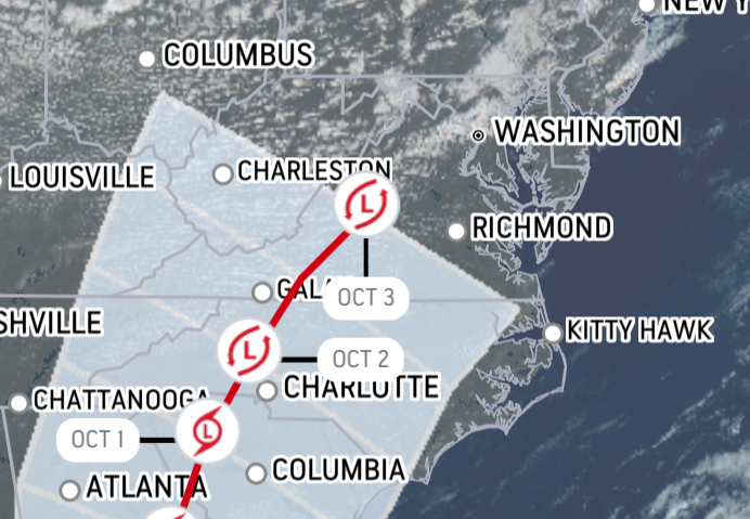
Ian's predicted path today and
overnight into Sunday

The National Hurricane Center reports Post-Tropical Cyclone Ian's current location is north of Greensboro, North Carolina, approaching the Virginia border at 10 MPH. Its current maximum sustained winds are only 25 MPH.

Rockville's forecast from the National Weather Service calls for rain or drizzle, and patchy fog for the remainder of this afternoon. Winds will be 16 MPH, with gusts up to 29 MPH. Tonight, rain turning to drizzle at 7:00 PM. Patchy fog will continue to pop up across the area, and the low temperature will be 54 degrees. Wind gusts will top out at 18 MPH.

Sunday morning, those wind gusts will get stronger again, with a maximum gust of 29 MPH. There will be a 90% chance of showers. Sunday night, wind gusts will remain strong at 28 MPH, but rain will taper off after 2:00 AM. Monday will stay breezy, but the forecast has improved with partly sunny conditions for most of the day, and a 30% chance of showers.

Ian caused many major events around the state to be canceled, including the Taste of Bethesda, and the Oceans Calling festival in Ocean City. Public officials and event organizers were put in a difficult position, and have chosen to err on the side of caution in many cases.

Graphics courtesy National Hurricane Center (top)/Accuweather.com (bottom)

Monday, September 26, 2022

Will Hurricane Ian hit the Washington D.C. area? This newest track shows it's very likely.


Hurricane Ian's current location is 325 miles south-southwest of Key West, Florida, according to the National Hurricane center. But after Ian hits the Gulf Coast of Florida - currently anticipated to occur Thursday - as a potential Category 4 storm upon landfall, will its path ultimately affect the Washington, D.C. area, including Rockville and Montgomery County in Maryland? Accuweather's latest track shows a very good chance that it will.


The last position forecast on the map at this time predicts Ian will pass east of Atlanta, west of Charlotte, and be aimed directly at the Washington, D.C. area as it arcs back toward the Atlantic Ocean. At that position on October 3, 2022, Accuweather shows Ian directly north of Lynchburg, Virginia. Extending the path from that point on the same curvature would show the remnants of Ian making a direct hit on the Washington, D.C. area. Accuweather predicts Ian will have maximum sustained wind gusts of 35 MPH as of that time, and maximum wind gusts of up to 46 MPH - certainly well below hurricane-force winds, but still a risk for downed trees and power lines.


Of course, forecasters can't even guarantee the exact point where Ian will make landfall in Florida yet, so much of this model's track could easily change. But what it does show is that there are strong odds the storm will greatly impact our area for at least one day next week, with the potential for high winds, heavy rain, flooding and tornadic activity. Now is the time to think ahead, and ensure you have batteries, a half-tank of gas in your car, some extra non-perishable food on hand if power goes out, and a battery-powered radio.

Images courtesy of Accuweather.com

Sunday, March 16, 2014

ROCKVILLE SNOW UPDATE - HOW MANY INCHES OF SNOW IN ROCKVILLE?

A winter storm warning is in effect across the region today from 2:00 PM until 2:00 PM Monday. Rain is forecast to begin this afternoon, and change over to snow as the sun sets. The heaviest snow will fall during the overnight hours tonight. Currently, the National Weather Service is calling for accumulation of 5 inches, or more. Temperatures will be in the 20s overnight.

Winds during the storm will gust up to 20 MPH, but average around 10.

Highs on Monday will remain in the lower 30s, meaning travel will be dangerous, and road conditions could remain hazardous throughout the day.

Stay tuned for updates on this very late winter storm.

Wednesday, February 12, 2014

ROCKVILLE DECLARES SNOW EMERGENCY + HOW MANY INCHES OF SNOW TO EXPECT

The City of Rockville has declared a snow emergency, as a major winter storm approaches the city. A snow emergency means residents should remove vehicles from streets by 6 PM tonight. If there is not adequate space to do so, residents are asked to park on the even-numbered side of the street. These non-mandatory requests are meant to make it easier for snowplow drivers to navigate streets, and speed up the snow removal process.

What is mandatory, is the city's snow-shoveling law:

Snow must be removed from sidewalks, steps, driveways, parking spaces and similar paved areas for public use (including access ramps and curbs) within 48 hours after a snowfall of three to 10 inches and within 72 hours after a snowfall of more than 10 inches. When clearing paved areas, provide a safe, unobstructed, passable path 36 inches wide.

Residents are asked to avoid driving during the storm, if possible. If you have a non-emergency weather-related issue to report to city police, call 240-314-8900. For emergencies, obviously, call 911.

Maryland Gov. Martin O'Malley has declared a snow emergency for the state, as well.

ROCKVILLE FORECAST

Heavy snow is expected to begin falling during the evening rush hour tonight. Current projections are for 3-6" tonight, and 4-8" Thursday, for a total of up to 10". The high today will be 30-32 F, and the high Thursday will be 34 F.

Wednesday, February 5, 2014

ROCKVILLE ICE/WEATHER UPDATE (PHOTO)

It is currently 32° in Rockville. Expect rain or freezing rain intermittently over the next few hours, but this further precipitation shouldn't stick once the temperature increases.

Temperatures will remain above freezing all day, and the Winter Storm Warning expires at 10:00 AM this morning.

We're not thawed out yet, though, as you can see on this Ride On sign.

Wednesday, March 6, 2013

ROCKVILLE SNOW UPDATE - WINTER STORM SATURN

Well, so far the weather experts have been dead wrong on Winter Storm Saturn. Rain starting at 5 PM yesterday? Never happened. 1-3" of snow last night? Nope. Now they're telling us the worst is still to come today. I don't have much faith in these "experts."

Roads are slick but quite passable at this hour.

Schools and the federal government are closed. The Maryland state government is on liberal leave.

Almost all Metrobus routes are running, but some are on "limited" schedules. That means more waiting than usual at bus stops.

Forecast remains the same, with snow accumulation of 5-6" by tomorrow, while other models say anywhere from 3-12".

Stay tuned here and at @RockvilleNights on Twitter for updates.

Tuesday, March 5, 2013

HOW MANY INCHES OF SNOW WILL ROCKVILLE GET FROM WINTER STORM SATURN?

Rockville is under a Winter Storm Watch right now. The sun is shining, but there's a wintry chill in the air.

Winter Storm Saturn is on its way to the DC area.

How many inches of snow will end up falling on Rockville tonight and on Wednesday?

The average prediction is 5-6 inches. Some forecasters say it could be as many as 8-12.

But here's an intriguing prediction: the now-famous Euro Model is saying the DC area will receive a 1-3" accumulation. This contradicts the majority of forecasts. Yet it is intriguing because the Euro Model was dead-right about the hurricane last fall.

The fact is, nobody knows. But conditions are right for up to a foot of snow.  And it is supposed to be a wet, heavy snow. That means more effort to shovel and plow for humans and machines.

Even though the Euro Model sounds unlikely, you can't rule out the data from a model that has been accurate so many times.

The fact that temperatures will rise above freezing on Wednesday could certainly reduce the potential total accumulation.

But that ice and slush will freeze solid after dark again, so watch out.

Today, expect light showers by 5:00 PM, changing over to snow after dark.  Accumulation of 1-2" possible tonight. Winds gusting to 30 MPH.

Wednesday, heavy showers and heavy snow. Accumulation of 5-12" possible through Thursday morning. Winds will gust to 35 MPH. Visibility could be affected if snowfall is heavy, due to winds.

Metro and Metrobus are total wildcards in recent years, in contrast to their past practice of operation during all but the worst snows in prior decades.

Stay tuned here and at @RockvilleNights on Twitter for updates throughout the storm!