Monday, October 3, 2022
Assault at Rockville grocery store
Rockville City police responded to a report of a 2nd-degree assault at a grocery store in the King Farm neigbhorhood yesterday afternoon, October 2, 2022. The assault was reported at a supermarket in the 400 block of Redland Boulevard at 2:20 PM. There is a Safeway store at 403 Redland Boulevard.
Sunday, October 2, 2022
Gourmet Bazaar opens in new location in Rockville
Gourmet Bazaar has relocated in Rockville. Back in March, I reported that the Persian deli and grocery store would be moving to 736-A Rockville Pike, and now the move is complete. The family-owned business was founded in 2013. In addition to groceries, they offer a full menu of freshly-prepared carry-out items, so you can pick up a hot lunch or dinner while restocking your pantry.
Saturday, October 1, 2022
Hurricane Ian now Tropical Rainstorm Ian In North Carolina, minimal impact so far on Maryland, Rockville
Hurricane Ian is blamed for the deaths of more than 14 people in the southern United States so far, but as Tropical Rainstorm Ian, its outer bands have not made much of a scratch on the Maryland, Washington, D.C. and Virginia areas yet. At this hour, there is only 1 power outage in Montgomery County, caused by a fallen utility pole in the Four Corners area of Silver Spring. Rain has not been constant, and winds have been more breezy than gusty to this point.
 |
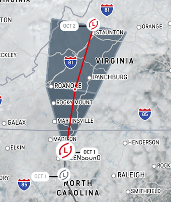
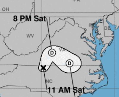
| Ian's predicted path today and overnight into Sunday |
The National Hurricane Center reports Post-Tropical Cyclone Ian's current location is north of Greensboro, North Carolina, approaching the Virginia border at 10 MPH. Its current maximum sustained winds are only 25 MPH.
Rockville's forecast from the National Weather Service calls for rain or drizzle, and patchy fog for the remainder of this afternoon. Winds will be 16 MPH, with gusts up to 29 MPH. Tonight, rain turning to drizzle at 7:00 PM. Patchy fog will continue to pop up across the area, and the low temperature will be 54 degrees. Wind gusts will top out at 18 MPH.
Sunday morning, those wind gusts will get stronger again, with a maximum gust of 29 MPH. There will be a 90% chance of showers. Sunday night, wind gusts will remain strong at 28 MPH, but rain will taper off after 2:00 AM. Monday will stay breezy, but the forecast has improved with partly sunny conditions for most of the day, and a 30% chance of showers.
Ian caused many major events around the state to be canceled, including the Taste of Bethesda, and the Oceans Calling festival in Ocean City. Public officials and event organizers were put in a difficult position, and have chosen to err on the side of caution in many cases.
Graphics courtesy National Hurricane Center (top)/Accuweather.com (bottom)
Friday, September 30, 2022
The B-12 Store opening Saturday at Montgomery Mall in Bethesda
The B-12 Store will open at Westfield Montgomery Mall in Bethesda tomorrow, Saturday, October 1, 2022. Special grand opening promotions will run for the next week at the store, which sells and administers injectable and intravenous vitamins. The store is overseen by a physician who can write prescriptions for the vitamins, and all injections and IVs are adminstered by certified nurses.
All supplements are manufactured by Legere Pharmaceuticals and Vox Nutrition in an FDA registered outsourcing facility. Look for the B-12 Store on Level 1, next to Haagen-Dazs.
Hurricane Ian outer rain bands to reach Maryland, Virginia today as eye makes landfall in South Carolina
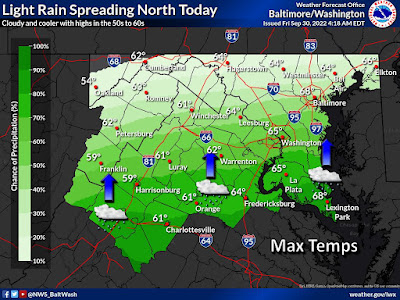
The first outer rain bands of Hurricane Ian will reach the Washington, D.C. metropolitan area around the middle of this afternoon, as D.C., Maryland and Virginia get their first splash of what will be a very wet weekend. Around the same time, Ian will make its third landfall on the coast of South Carolina. Accuweather forecasts a storm surge of 3 to 6 feet in South Carolina, with the greatest impacts north of Charleston, and in the vicinity of Georgetown and Myrtle Beach. The South Carolina and Georgia coasts could experience a total rainfall of 8 to 12 inches, and up to 18 inches in some spots. Rainfall will likely total 4-8" in North Carolina, Eastern Tennessee, Virginia and West Virginia.
Here in Maryland, the localized flood risk will first loom tonight, and today will feature the highest wind gusts of 37 MPH. Winds will drop to gusts of 21 MPH on Saturday and Sunday, Total rainfall in Maryland and Montgomery County is expected to be about 2 inches over the weekend. However, if Ian were to move out over the ocean again or stall over our area, that total could more than double. So be prepared for all potential outcomes.
As of 5:00 AM this morning, the National Hurricane Center reports Hurricane Ian's current location is 145 miles SSE of Charleston, South Carolina. It is moving NNE at 9 MPH. Ian's current maximum sustained winds are measured at 85 MPH.
Graphic courtesy National Weather Service
Thursday, September 29, 2022
Car stolen outside Rockville apartment building
Montgomery County police are investigating the theft of a vehicle from the parking lot of an apartment building in Rockville yesterday, September 28, 2022. The vehicle was taken from a residential parking lot in the 1300 block of Piccard Drive. That appears to be the Flats at Shady Grove apartment building. It is believed the vehicle was stolen sometime between 7:00 PM Tuesday night and 5:30 AM Wednesday morning.
Hurricane Ian remnants to impact Maryland sooner than expected, after stops in Georgia, the Carolinas, Virginia
The worst of Hurricane Ian may have already passed in Florida, but the now-Tropical Storm is expected to make a speedy trip up the East Coast, including a jaunt out to sea and another landfall somewhere in the South. Yesterday, Ian's timetable for arrival in the Washington, D.C., Maryland and North Virginia area began to look like it was slipping from early next week to this weekend. Now, Accuweather is forecasting the first rains of Ian to arrive in the Mid-Atlantic as early as tomorrow.
Tropical rain showers are now expected all weekend, and showers may continue from Monday into Wednesday. This does not look good for events like Taste of Bethesda this Saturday. Rain associated with Ian will arrive well ahead of the actual storm center, which is expected to pass through Maryland sometime Sunday night or early Monday morning.
Ian has further business south of here first, however. After crawling across mainland Florida, the storm will go back over the Atlantic, and make another landfall tomorrow evening. Accuweather currently predicts Ian's landfall will be somewhere near the border of Georgia and South Carolina Friday night; the National Hurricane Center's prediction is for a landfall in South Carolina.
The full impact of Ian's second landfall, and the strength of the storm's remnants when it arrives here in the D.C. area, will be determined by how long it drifts over the waters of the Atlantic prior to Friday night's landfall. The National Hurricane Center says the storm could again near hurricane strength as it approaches land.
Ian already has shown plenty of destructive power after making landfall as a Category 4 hurricane. Over 2 million utility customers in Florida are currently without electricity. Accuweather reports that every customer in Hardee County, Florida is in the dark. Part of the Sanibel Causeway collapsed, the only bridge between Sanibel Island and mainland Florida.
Florida Gov. Ron DeSantis said earlier this morning that helicopter rescues are being performed on barrier islands by the Coast Guard and Florida National Guard. He said 100 portable cell towers are being set up to restore some level of phone service, and that power line infrastructure in the hardest hit areas would in some cases have to be entirely rebuilt. Pine Island Bridge, like the Sanibel Causeway, is damaged and impassable, he added.
Fox Weather reports that there are believed to be hundreds of fatalities in Lee County, Florida, according to the sheriff there. Accuweather reports one confirmed death in Florida from Hurricane Ian, a 72-year-old man in Deltona. He slipped down a hill behind his home into a flooding drainage ditch while trying to drain his pool as the storm approached his area at 1:00 AM this morning. Fox Weather also reports Ian has caused a 200-year flood event in Orlando. More than a foot of rain has fallen on the city.
DeSantis said his state has all of the supplies it needs for storm victims. "It's much better to donate financially, rather than sending items. We've got a lot of items," he said at a news conference this morning. Those seeking to help storm victims displaced in Florida can have the greatest impact by donating funds at FloridaDisasterFund.org, or text DISASTER to 20222, he said. Florida First Lady Casey DeSantis said the fund has already raised $1.6 million in the last 24 hours.
Tropical Storm Ian's current location is 40 miles east of Orlando, the National Hurricane Center reports. Its current maximum sustained winds are at 65 MPH, and it is moving NE at 8 MPH.
Graphic courtesy Accuweather.com


