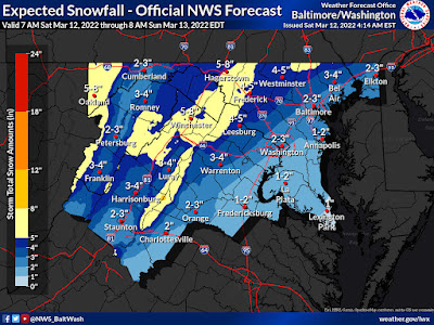
A winter storm affecting the entire state of Maryland today is now expected to result in 2-3" of snow accumulation in Bethesda and Rockville, according to the National Weather Service. Parts of Montgomery County further north could receive between 3" and 5", the agency said at 4:34 AM this morning. Accuweather is predicting a smaller total of "an inch or two." Of greater concern will be the high winds, which are expected to gust up to 55 MPH at times.
 |
| Maryland Gov. Larry Hogan (R) |
Maryland Gov. Larry Hogan (R) advised residents to "[s]tay tuned to your local news stations for updates, heed warnings from state and local authorities, and most importantly, use common sense." Meteorologists are describing the storm as a "bomb cyclone." What is a bomb cyclone or bombogenesis? A storm that strengthens quickly at its beginning, with a rapid fall in barometric pressure over a shorter period of time, is how Accuweather defines the terms. The high winds expected today are a typical characteristic of a bomb cyclone storm.
Because of the high winds, which may continue until 1:00 AM Sunday morning, any loose objects in yards or on balconies should be tied down or brought indoors as early as possible this morning. Winds are expected to cause power outages and falling trees across the area through early Sunday. We are now under a wind advisory and winter weather advisory.
No comments:
Post a Comment